White Rock (Ak-Kaya). Central Crimea. Ak-kaya - white rock Where is Mount Ak-kaya located
The Crimean mountains are fraught with many interesting and unknown things. They protect the peninsula on the southern side and delight with their sometimes bizarre shapes. One of the particularly remarkable and memorable rocks is called Ak-Kaya. Ak-Kaya is located near the village of Belaya Skala in the Belogorsky district.
Geographic coordinates of White Rock - Ak-Kaya on the map of Crimea GPS N 45.098056, E 34.633333
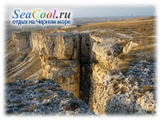
Name Ak-Kaya translated from Crimean Tatar as “white rock”. Moreover, it is under this name that it is better known among tourists and local residents. And the village White Rock got its name precisely due to the proximity of Ak-Kai. Approaching these places in the Belogorsk region, Ak-Kai simply cannot be missed. It is a steep white cliff with a very flat top. Ak-Kaya serves natural decoration valley of the Biyuk-Karasu river. The height of the White Rock reaches three hundred and twenty-five meters, so if you approach its foot and look up, it will seem infinitely high. From a distance, Ak-Kaya looks perfectly flat, but in fact it is filled with many rapids and ledges.
It must be said that only the most courageous and prepared climbers dare to conquer this peak. The white color of Ak-Kaya is due to the fact that it is composed of limestone and sandstone, and is the result of their weathering and erosion. At the top of Ak-Kaya there are various natural grottoes and rounded niches, and below you can see rocky mounds and accumulations of large stones. Such an unusual and massive appearance of Ak-Kai attracts many filmmakers here. The rock became a film set during the creation of such films as “The Headless Horseman”, “Code of the Apocalypse”, “The Leader of the Redskins”, “Escape to the End of the World” and some others.

In the second half of the 20th century, the White Rock aroused considerable interest among archaeological researchers. At this time, excavations were carried out here, the progress of which was led by Yu. G. Kolosov, an employee of the Institute of Archeology. Two dozen sites of ancient people who, according to researchers, belonged to the Mousterian era were discovered here. Stone knives and tools were found on the rock. For the first time, the bone remains of Neanderthals were excavated here. There is also confirmation that mammoths, giant deer, cave bears, saigas and other animals that are not typical for modern fauna once lived here. There is an assumption that settlements of the Sarmatians and Scythians were located on Ak-Kaya.
How to get to the White Rock - Ak-Kaya

The easiest way to get to Belaya Skala is from the city of Belogorsk, in the north of the city, there is an exit towards the villages: Yablochnoe and Belaya Skala, 4 km from Belogorsk and you are in the village of Belaya Skala, the Ak-Kaya rock simply hangs over the village, you can drive through it or not notice it It's simply not possible. A dirt road leads to the top of the mountain from the village; it lazily goes for several kilometers and rises to the large plateau of the Ak-Kaya rock. there are many observation platforms on the plateau, there are even observation decks for cars. In late spring and early autumn, the dirt road is severely washed out, so it is best to get there by all-wheel drive; in winter, even on it it is very dangerous.

In the middle of the White Rock wall there is a hard-to-reach cave called Altyn Teshik (“golden hole”). There are several legends about it, one of which says that the treasures of robbers are hidden there.
Over many centuries, Ak-Kaya continually changed its purpose. It was also a place of execution and ceremonial oath-taking, and a home and even a military headquarters. White Rock is one of the most famous and visited.
As much as I traveled around Crimea, I always had the feeling that on this island of land someone had collected geological and landscape beauties from almost all over the world - such different reliefs and views can be found here.
One of such places can be called White Rock, which we will talk about today.
Almost in the middle of Crimea, between the Main mountain range and the endless steppes, an extremely unusual cue formation rises more than 300 meters, reminiscent of the world-famous landscapes of Arizona (albeit, with the exception of the color scheme) - the vertical wall of Ak-Kaya, or White Rock.
It's hard to imagine, but this rock was once the seabed, as evidenced by great amount fossilized shells and mollusks that come across here just under your feet.
Since Soviet times, this place has been chosen by directors making films about the American West, Indians and more - in different time“The Man from Capuchin Boulevard”, “Mustang Pacer”, “Leader of the Redskins”, “Mirage”, “Cipollino”, “Armed and Very Dangerous”, “Kings and Cabbage”, “Lobo”, “Moneychangers” were filmed on White Rock , “Wonderful Valley”, “The Headless Horseman”, “The plane flies to Russia”, “Dungeon of the Witches”, “Escape to the End of the World”, “Code of the Apocalypse”, etc.
2. White Rock is located in the Belogorsk region of Crimea above the valley of the Biyuk-Karasu River. If you get to it from the north, you will not immediately understand that you are heading towards an incredible cliff - you are driving along steppe roads, rolling over hills, and suddenly... there is a sheer wall below you.
From the south, the rock looks exactly as in the photo - Ak-Kaya itself is on the left, Mount Adjilar is on the right. Between them there is a crumbling winding road, along which we used to climb to the plateau. Now there is an asphalt road to the right of Adjilar, from which a dirt road branches off at the top, running almost along the edge of Adjilar and Ak-Kaya. 
3. White Rock was formed by erosion and weathering of Cretaceous limestones and sandstones over many thousands of years. If you stand under the rock itself, at the foot you can clearly see the mounds of what were once rock walls 
4. Plateau on Mount Acilar. Here, at the foot of Ajilar and further, in the depression between it and Ak-Kaya, the very films that I said at the very beginning were filmed 
5. Views from the plateau of Mount Acilar 
6. Geometry of fields 
7. And in the distance you can already see the White Rock 
8. This is where the same giant repeater is located, which I mentioned earlier 
9. At the foot of the White Rock, more than one city was built with scenery for filming. Everything that you saw, for example, in “The Man from the Boulevard des Capuchins” was located in this place under the rock. 
10. Views from White Rock 
11. The end of the rock wall. It feels like someone just cut off all the excess with a knife 
12. The altitude here is about 325 meters above sea level 
13. The old road that led to the rock. Today you can climb it only with a well-prepared SUV. 
14. Faults in the upper part of the plateau. There are generally a lot of faults, natural grottoes and caves here. 
15. Rock wall of White Rock. The scree created by the wind is clearly visible below. 
16. One day these “small” pieces will fall off and fly down with a roar. 
17. At the foot of the White Rock in the 70s, about 20 sites of primitive man of the Mousterian era were excavated.
And near the ancient hearths a large number of bone remains of the extinct fauna of Crimea were found: mammoth, cave bear, giant and red deer, saiga, primitive bull, wild horse, onager, etc. 
18. One of the faults on the rock wall 
19. But once upon a time this was the seabed. Yes, it's hard to believe, but it's true. Here and there under your feet you come across such boulders of stone, which consist entirely of fossilized shells 
20. Clam frozen in stone 
21. In some places it’s just part of a rock 
22. Some mollusks themselves became pebbles 
23. White Rock, view from the highway. This is exactly how most people passing by see it. 
24. Layer cake created by wind and time... 
![]()
> >
One of the most interesting natural attractions of Crimea is the White Rock near Belogorsk. It is clearly visible from the Kerch-Simferopol highway, but we advise everyone - take the time, turn towards it, admire it closer!
White Rock on the map of Crimea:
April-May is the best time for an excursion to the White Rock (Ak-Kaya, Turkic). In the spring, its rather modest vegetation has not yet withered in the sun, and most importantly, Voronets bloom in Krasnaya Balka - amazingly beautiful wild peonies.

White Rock - a miracle of Central Crimea
We arrived at Belogorsk at 8 o'clock, when the rock was still in a light morning haze, so we decided to start exploring the surrounding sights with a visit to the Suvorov Oak. The highway all the way from and partly to Belogorsk now resembles a huge construction site - the Tavrida highway, bridges across rivers, and a canal are being built:

Crimea has not seen anything like this for a long time.
Suvorov Oak and Biyuk-Karasu
The 800-year-old oak itself is simply amazing (diameter 4 m, circumference 10 m, crown 40 m), you feel like an ant next to it:

It is not only botanical, but also historical monument- under him is our famous commander A.V. Suvorov in 1777 accepted capitulation from the envoys of the Turkish Sultan. This happened after a 10,000-strong Russian army defeated a 40,000-strong Turkish army not far from this place.
From the oak tree we went to the rock, but crossing the bridge over the Biyuk-Karasu River, we decided to first drive up to it, it winds too beautifully in these places:

Then they turned to the rock itself, to the very place that resembles the bow of a ship. Its height above sea level is 325 meters, above the valley more than 100 meters. In Crimea there are many such cuestas - mountains, steep on one side and gentle on the other. We previously talked about an excursion to a similar one -. But White Rock is undoubtedly the most unusual.
Many probably recognized this landscape from Soviet and Russian films, of which more than a dozen were filmed here. That's why I was immediately indignant - I see Texas, but where are the cowboys on horses? Immediately, as if on my order, the horses appeared, but the unlucky “cowboy” ran screaming after.

At the foot of the White Rock, onosma bloomed - a plant listed in the Red Book with funny yellow bells:

Yellow flowers noticeably predominate in the area, especially on the arid yayla - a flat mountain top, but more on that later.
Having admired the white bulk hanging overhead, we decided to climb into the grotto. In fact, there are a lot of grottoes, caves and other depressions in the White Rock. It is not for nothing that about 40 ancient human sites were found in these places.
Grottoes Altyn Teshik, Uch-Koba and Krasnaya Balka
There are two large caves at the nose of the cliff. The first, similar to a huge drop and inaccessible to ordinary tourist— Altyn Teshik. Robbers allegedly hid a rich treasure here. Now the cave is inhabited by birds (or like in a bird market).
The second is called the Lower or Large Grotto. There is a steep, but quite accessible path to it. At this time, her summer adonis (Adonis) and hybrid poppy were blooming (not the same self-seeding one that makes you turn red in May Crimean fields, but its earlier and smaller brother).

Once upon a time, judging by the excavations, there was a sanctuary of the Sarmatians in the grotto. Now at the entrance to the grotto there is a huge hawthorn tree, just as it was blooming its first flowers.

Inside, unfortunately, everything is not so great. Too many "Neanderthals" visit it these days.

Near the grotto, mice were lying, dropped kestrels, several pairs of which were actively scurrying around, now flying away, now returning to the rock, where they were greeted by the sharp cries of the chicks.

We drove further along the mountain by car, admiring the bizarre outlines of rocks and grottoes (this group of grottoes is called Uch-Koba), and stopped at the foot of the Red Beam. It is named after the vorontsy (angustifolia peony), which covers it with a crimson-scarlet carpet for one or two weeks every spring:

We're a little late, so most of the peonies had faded and the beam looked rather modest:

But in the bushes at the foot of the yayla, spring adonis, also a rare protected plant, began to bloom.

On the plateau (yayla) of the White Rock
Another minute or two and we are on the yaila, from where the surrounding area has an extraordinary view beautiful view. That is why, although you can climb to the top by car, we advise you not to do this, but to walk along the cliff.

This walk will take an hour at most, but the impressions will last a lifetime.

Ak-Kaya massif, composed of Paleogene and Cretaceous limestones, part of a low but picturesque internal ridge Crimean mountains, separating the Main Ridge.

The plant community of the plateau can be safely attributed to the type of asphodeline steppes, thanks to this plant, asphodeline, reminiscent of young pine trees:

They were just beginning to bloom, delighting the bumblebees, whose long proboscis can only reach the deeply hidden nectar:

Among the insects we also met, the Red Book Crimean swallowtail butterflies and a friendly company of large caterpillars of the ringed silkworm (or some of its relatives). Apparently they have already eaten everything where they hatched and have just marched to a new place:

We brought binoculars, so we had the opportunity to admire not only the life of insects, but also birds.

The most interesting (and beautiful) were the kestrels, which completely ignored us and flew along the rocks, from time to time teaming up with their neighbors to drive crows and crows away from their nests. There were also quite a few swifts there, but it was difficult to see the black lightning, but you could clearly hear the loud “swish” of their wings.

Here is the edge of the White Rock, resting on the sharp bow of the “ship”:

Once upon a time, the heads of the Tatar clans were elected here, here, in front of Bogdan Khmelnitsky, prisoners were thrown off a cliff in order to hasten his ransom, here in 1783, representatives of the Crimean Tatar nobility took an oath of allegiance to the Russian Empire before Prince Potemkin.
Now on the right hand you can see how the fields are turning green, the pine forest is darkening in the distance:

On the left, the following lunar landscape prevails:

By the way, it’s convenient to start excursion route along the wide path running between these hills and the White Rock, climb up it, then go through the plateau, go down the Red Beam and return to the beginning of the route along the road along the rock. We drew it on the map.
We went back not along the cliff, but approximately in the center of the plateau and almost immediately began to stumble upon local orchids:


In general, there are many orchids in Crimea and all are protected by law; you cannot pick them.
About a 7-10 minute leisurely walk from the edge of the cliff there is a quarry where stone was once cut for neighboring settlements:

Since Karasubazar (now Belogorsk) was the trading capital of the Crimean Khanate for a long time, it required a lot of stone.
Interesting fossils found nearby:

These are nummulites (because they resemble coins), shells of single-celled organisms of the order Foraminifera. Imagine, 100 million years ago, single-celled (!) organisms built houses that resembled spiral flying saucers, the size of a silver royal ruble! By the way, Egyptian pyramids built from such nummulitic limestone.

With our meager knowledge of paleontology, we, alas, were unable to determine the name of this fossil; perhaps it was part of a spirifera shell.
Finally, we admired how the rock crystal found right there shimmers in the sun:


At the edge of the plateau we got a little lost, looking at the caves covering the edge of the ravine from above, found a descent, and suddenly, from the dry and almost bare steppe we found ourselves in the “jungle” - dense thickets of trees and bushes, which are carefully entwined with ivy, along the way moving onto the rocks.

There are a lot of caves, or rather grottoes, here, they are dry, cozy, it is not surprising that ancient people settled in them. Moreover, the plateau served convenient place hunting - surrounded the animal and drove it to the cliff.

Finally, after admiring the amazingly bright peonies again, we got into the car and drove on.
Ak-Kaya settlement and Kok-Koba grotto
Soon after Krasnaya Balka the rocks move apart and the road turns right towards Vishennoye. By left hand there will be a rock:

On it is the Scythian settlement of Ak-Kaya (3rd century BC, 3rd century AD). On the plateau itself, numerous round and square holes remind of this:

Some of the buildings have been excavated a little lower (opposite you can see the Kok-Koba grotto):

The size of this settlement was second only to Scythian Naples, excavated near Simferopol, and alternately belonged to the Scythians, Romans, and Khazars. total area The settlement is 10 hectares in size, which means we still have to dig and dig, and many interesting discoveries await us. It may be possible to prove that this is the medieval fortress of Fulla, mentioned in the chronicles as standing near a “cave with a spring.”
Having examined the ancient settlement, we went to that very “cave with a source” - to the Kok-Koba grotto:

It is huge and extremely picturesque:

When we entered through a small side entrance, a herd of cows was resting there, then our company was joined by a herd of schoolchildren, much more playful and noisy:

The uniqueness of the grotto is that water oozes directly from the walls, drips from the ceiling in places, and in the center forms a waterfall of drops, collecting in a small bowl carved into the rock and flowing in a stream into a reservoir overgrown with reeds at the foot of the grotto.

All this is unusual and very beautiful.

The Kok-Koba Grotto was the last point of our journey. Through Vishennoye we went onto the highway, and after admiring the White Rock from it once again, we went home full of impressions.

White Rock or Ak-Kaya is located, surprisingly, near the village of Belaya Skala, not far from Belogorsk. It stands out noticeably against the background of the gentle and low hills surrounding it.
This place is not very popular with tourists, so it is usually clean and uncrowded. Belogorsk is located quite far from resort towns and away from standard tourist routes. Locals come here mainly on weekends, and visitors usually simply do not know about this place. Despite this, the village has a recreation center where you can book horseback riding or quad bike rides. You can stay here and if you want to go to Taigan Park, located 15 km away, unlike their hotel, the prices at the base are not too high.
You can walk around the rock itself and its surroundings for a couple of days, during which time you can easily get around everything interesting that is there. There are several small grottoes and caves in the rock, some of them can be approached, but some cannot be reached without special equipment. For example, at an altitude of about 50 meters from the ground you can see the Altyn-Teshik (Golden Hole) cave.

This is a rocky plateau, with white cliffs on one side, but quite flat on the other side. There are quite a few paths and roads around the rock, some of which can be used to climb to the top. The shortest path to the top is clearly visible on the snow-white hill at the foot of the cliff; it is not too steep and the climb will take a maximum of half an hour. But actually, best views here they open from the bottom, and not from the top, because You can't see much from the top, just gentle green hills.
You can go to the White Rock by car, but you need to go along the road that goes perpendicular to the cliff line, about a hundred meters from the rock itself. IN good weather You can drive here in any car. Many maps show a bypass route closer to the village of Vishenny, but you can only drive along it on an ATV or a well-prepared SUV; the climb is very steep and rocky.
How to get to White Rock?

By car:
First you need to get to Belogorsk and turn north, towards the village of Belaya Skala. The rock itself can be seen from afar; you definitely won’t be able to miss it. You can approach it either through the village, or by turning right at the first turn after leaving settlement. In the second case, you will be able to drive along the entire rock massif, although the road there is a little worse.
You can also get to Belogorsk by buses, they go from Simferopol and Sudak. From Simferopol you can get directly to Belaya Skala; buses depart approximately every hour from 8.00 to 19.30. From Sudak you can only get to Belogorsk by almost any bus towards Simferopol. From Belogorsk to Belaya Skala is about 5 km, if you wish, you can walk or take a taxi.
Excursions and hikes are a journey from your life to someone else’s. It’s as if you were torn out of monotonous everyday life, transported to the south, and placed on the sidelines to teach you how to properly relate to life and everything that happens in it. And you know, the place of these lessons was not chosen by chance: man appeared in Crimea a very long time ago, and the “aura” of the peninsula is thoroughly saturated with billions of lives lived. One of the first places where our civilization began to exist is the surrounding area mountain range Ak-Kaya in Crimea. Today, also known as White Rock, is popular natural object, to which numerous are drawn tourist routes. The excursion to it is memorable for its unusualness, the special atmosphere of touching something that has long sunk into oblivion, and the beauty of the surrounding landscapes. Interesting? Welcome to virtual tour To !
Geography of Crimea: White Rock of Ak-Kaya
The rock is located near the village White Rock 42 kilometers from the capital of Crimea - the city of Simferopol. Geographically located in Belogorsky district. It is a rocky wall of white (with a slight cream tint) color, towering over the spacious valley of the Biyuk-Karasu River. It has an altitude of 325 meters above sea level and relative height(above the surrounding area) about 100 meters. translated from the Crimean Tatar language as “White Rock”.
, is the result of erosion and weathering of sandstones, Paleogene and Cretaceous limestones, a classic example of cuesta relief. The wind is an original sculptor. If on Mount Demerdzhi he created bizarre stone idols and “populated” the Valley of Ghosts with them, then in the upper part he “drilled” oval niches, grottoes, and placed pillars. Screes, erosion hollows, chaotic piles of blocks are weathering products found in large quantities in the lower part of the rock. Erosion, held back in places by hornbeam and rosehip thickets, continues today.
Of the many voids that have eaten into the cliffs of Ak-Kai, about fifty have been examined by geologists. Large caves on White Rock only three. They are located at the base of a rock ledge and are called and. Archaeological research carried out in the mid-1940s discovered on their walls Sarmatian petroglyphs, applied in different eras - from the 3rd century BC to the beginning of our era.
The third grotto, the most mysterious and inaccessible, is called Altyn-Teshik. The back entrance to it is visible from afar, and the name, translated as “Golden Hole,” reveals the “special” attitude towards it that developed in ancient times. Dozens of legends in different forms tell about treasures hidden in the cave, about the dragon that once lived in it and about the secret underground passage, stretching all the way to Feodosia. The research of speleologists dispelled these legends and revealed the truth: Altyn-Teshik is a large grotto, the arches of which go steeply upward, and the only dragons living in its darkness are bats. Since 1981 it has been declared a natural monument and is under state protection.
History of the Ak-Kaya rock

As mentioned at the beginning, an excursion to is an opportunity to get in touch with the past, tens of thousands of years distant from the present. Archaeologists have discovered 17 sites and entire settlements in and around the area dating back to the Mousterian era (about 100 - 40 thousand years ago) - a real Mousterian city. Its inhabitants were the predecessors of the Cro-Magnons - the Neanderthals, a fossil species of man. Such a high population density is easily explained by the exceptional convenience of the area for the life of ancient people: many grottoes on the warm southern side of the mountain range, rich deposits of flint (the main raw material for weapons and tools), and the proximity of the river. About 5 thousand flint scrapers, knives, and points were found around. The variety of their forms is amazing: eight types of knives were discovered on the White Rock itself.
Recently, a large Scythian fortress was excavated on the plateau, the study of which is currently ongoing by the branch Information Agency of the National Academy of Sciences of Ukraine. The appearance of this fortress dates back to the 4th-3rd centuries BC. On the territory of the northern Black Sea coast this is the only fortress of this period. The explored area of the fortress is about 10 hectares. There is an assumption that this is one of the forgotten Scythian capitals (for comparison: Scythian Naples, which appeared two hundred years later, occupied an area of 14 hectares). The life of the fortress was not calm: during the first century and a half of its existence, there were at least six fires in which everything was burned to the ground. A large number of The burials of crippled warriors indicate that battles took place here frequently. The fortress and the settlement inside it were abandoned by people in the Middle Ages, when a city was formed nearby Karasubazar. There are suggestions that it was at his slave market that young Bogdan Khmelnitsky was sold into slavery to Murza Yurus.

In 1777, the headquarters of Alexander Suvorov was not located, and in June 1783, the Crimean nobility swore allegiance to Russia on the top of the cliff. Prince Potemkin, a star of Soviet cinema, took the oath. It became the location for the filming of such wonderful films as " The leader of the Redskins», « Mustang pacer", "Chipolino", " The Man from the Boulevard des Capucines», « Headless horseman», « Kings and cabbage», « Armed and very dangerous", "Lobo". Some of the locals like to talk about how they starred in episodes of these films as boys.
How to get to Ak-Kai

The excursion falls into the easily accessible category - the road leads straight to its top. You can get to this road along the Feodosia - Simferopol highway (to the city of Belogorsk). The White Rock is already visible from the highway.
You can get from Simferopol to Belogorsk by regular bus. On central square Belogorsk, take a taxi and ask to take you to the foot of : this is where you will see grottoes and former sites of ancient people. You can climb it later - the rise will be about 90 meters.